
Stavanger visitor & cruise guide
Pulpit Rock (Preikestolen) from Stavanger: Hike It, See It by Fjord, or Plan a Cruise Day
A practical, conservative guide to Preikestolen from Stavanger: how to reach the trailhead, what the hike is really like, whether it fits a cruise stop, and the lower-effort Lysefjord cruise that shows Pulpit Rock from below.
Preikestolen is close enough for a day trip from Stavanger, but it is still a real mountain hike with transport, weather, and timing to plan.
Quick answer
There are three normal ways to experience Pulpit Rock / Preikestolen from Stavanger:
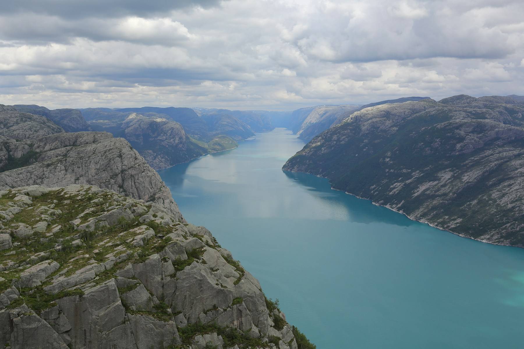
- Hike it: stand on the plateau, 604 m above the Lysefjord. Magnificent, but a full mountain day: the hike alone is about 8 km round trip and 4–5 hours, on top of transport to and from the trailhead.
- See it by fjord: a 3–3.5 hour Lysefjord cruise from the harbour shows the cliff from below, with far less time and risk.
- Stay in town: the lowest-stress choice for short or weather-risky days. See things to do in Stavanger on foot from the quay.
On a cruise? If your ship is in port for under 8 hours, do not plan an independent hike. Take the Lysefjord cruise or stay in Stavanger. The hike only becomes realistic with roughly 9–10+ hours ashore, an early arrival, good weather, and confirmed transport.
How far is Preikestolen from Stavanger?
Preikestolen sits across the fjord area from Stavanger, in the Lysefjord / Ryfylke region. The practical route from the city centre is by road through the Ryfast tunnel system (including Ryfylketunnelen) toward Solbakk, Jørpeland, and Preikestolen Parking / BaseCamp — where the trail begins.
For planning, use roughly 40 km by road and about 50–60 minutes each way by bus or transfer. Don’t build the day on the tightest possible number.
Getting to the trailhead from Stavanger
Preikestolen express bus
Two companies run buses from central Stavanger to the trailhead. Go Fjords leaves from Olav Vs gate 3 and runs from April to October. It runs daily in June, July and August. In April, May and September it runs at weekends only, plus a few extra dates. Pulpit Rock Tours (Boreal) picks up at several stops in the centre, including the bus terminal. Tickets are sold online, not on board, and your seat is only good for the departure you booked. Check the live timetables before you plan the day. A weekday call in May can mean no Go Fjords bus at all.
Guided or transport-included tour
A guided or transport-included tour reduces planning friction if you’d rather not stitch together separate buses and trailhead timing. Check what’s actually included. Some products cover transport but leave the hike self-guided.
Drive yourself
If you drive, follow the tunnel route toward Solbakk, Jørpeland, and the signed exit for Preikestolen Parking. There’s a parking fee paid on site; confirm the current amount rather than trusting an old blog figure.
The Preikestolen hike itself
This is a mountain hike, not a city viewpoint walk. The official round trip is 8 km, with about 500 m of total elevation gain and roughly 4 hours of hiking; allow 4–5 hours including breaks and photos. The plateau sits about 604 m above the Lysefjord, and the route includes uneven terrain, forest and open mountain sections, stone steps, and weather exposure. Commonly rated moderate — but moderate still means proper shoes, fitness, and time.

On a cruise stop? The timing reality
If you’re arriving by cruise ship, return-to-ship risk changes everything. A conservative door-to-door estimate for the independent hike looks like this:
- Ship to pickup point: 10–20 min
- Waiting / boarding: 15–30 min
- Transfer to trailhead: 50–60 min
- Hike round trip: 4–5 hours
- Food, photos, weather slack: 30–60 min
- Return transfer: 45–60 min
- Ship buffer before all-aboard: 60–90 min
Conservative total: 8.5–10+ hours. That’s why the hike only suits long calls. To pressure-test it against your ship’s exact arrival and all-aboard time, use the interactive Port-Day Clock on the main Stavanger guide before booking anything.
The trail is busiest from 08:00 to 10:00 in summer. That is the same window a cruise-day hike has to start in, so expect company on the steps and at the viewpoint.
If you skip the hike
A Lysefjord cruise from Stavanger harbour is usually the safer way to see Pulpit Rock when you don’t have time or appetite for the hike. It doesn’t put you on top of the cliff. It shows it from the fjord below, but it’s mostly covered, runs in light rain, and fits comfortably inside a normal port day (conservatively 5–6 hours door-to-door, including a 60-minute ship buffer). If you go that way, it is worth knowing which Lysefjord boat trip to pick — sightseeing cruise, fast RIB, or the Flørli staircase.
Season, weather, and daylight
The easy-planning season is the warmer, longer-daylight part of the year, when buses and tours are more likely to run and trail conditions are simpler. The trail is open year-round, but winter and shoulder-season hikes can involve ice, snow, short daylight, wind, and low cloud. Weather changes quickly around the Lysefjord — if the forecast is poor, downgrade the plan rather than forcing the hike.
What to bring and safety basics
- Hiking shoes or sturdy trainers with grip, not smooth city shoes.
- Layers and a waterproof shell, even if Stavanger looks calm in the morning.
- Water and food. There are no toilets or bins on the trail, so carry out what you carry in.
- The trailhead has a kiosk and gear rental. You can rent boot spikes there when the trail is icy, with no need to book ahead.
- Check daylight, weather, trail conditions, and return transport before starting.
- Turn back if timing, weather, or fitness starts to look wrong.
FAQ
Can you hike Pulpit Rock on a Stavanger cruise stop?
Sometimes, but it is a full-day plan. For most cruise passengers it is only realistic with roughly 9–10+ hours in port, confirmed transport or tour timing, good weather, strong fitness, and a large return-to-ship buffer. On shorter calls, take a Lysefjord cruise or stay in town.
Is a Lysefjord cruise a better choice than the hike?
For many visitors, yes, especially cruise passengers. A Lysefjord cruise from Stavanger harbour usually takes about 3–3.5 hours and shows Pulpit Rock from the fjord below, without the mountain hike and trailhead-transport risk.
How do I get to Preikestolen from Stavanger without a car?
Use a seasonal Preikestolen express bus, or a tour/transfer that includes transport to the trailhead. Always check the current operator timetable before you plan the day. Departures and seasons change.
How far is Preikestolen from Stavanger?
Roughly 40 km by road from central Stavanger to Preikestolen Parking / BaseCamp, via the Ryfast/Ryfylke tunnel route — commonly about 50–60 minutes each way by bus or transfer.
How long and how hard is the hike?
The official trail is an 8 km round trip with about 500 m of total elevation gain and roughly 4 hours of hiking; allow 4–5 hours including breaks. It is described as moderate, but expect uneven mountain terrain, stone steps, and weather exposure. Proper shoes and fitness needed.
When is Preikestolen open, and can I hike it in winter?
The trail is open year-round, but winter and shoulder-season conditions can be icy, snowy, dark, and demanding. Use a professional guide in difficult off-season conditions if you are not experienced.
How much return-to-ship buffer should cruise passengers keep?
Use at least a 60-minute ship buffer for lower-risk plans and more for transport-heavy plans like the hike. Never plan to return at the last minute, and always confirm your ship’s real all-aboard time.
Sources checked
These are the public source families used for this guide. Always confirm live schedules, weather, and operator details before booking.
- Preikestolen365: Hiking to Preikestolen Official trail distance, elevation gain, round-trip time, difficulty, terrain, and year-round notes.
- Preikestolen365: How to get to Preikestolen Bus operators, road route via Ryfylketunnelen, and current-season transport guidance.
- Visit Norway: Hiking to Preikestolen National tourism-board source for Preikestolen hiking context.
- Fjord Norway: Preikestolen Preikestolen height, route context, access by bus/car, and all-year visiting guidance.
- Go Fjords: Preikestolen Express Bus Round Trip Operator check for seasonal express-bus service, meeting point, and transport-included details.
- Pulpit Rock Tours / Boreal Bus-operator check for Stavanger to Preikestolen transport and trailhead timing.
- Rødne Lysefjord cruise duration, departure point, and route details.
- Stavangerregionen Havn Cruise-quay context and central city access.
- OpenStreetMap / OSRM route check Used only to sanity-check the approximate 39–40 km road distance from central Stavanger to Preikestolen Parking.