
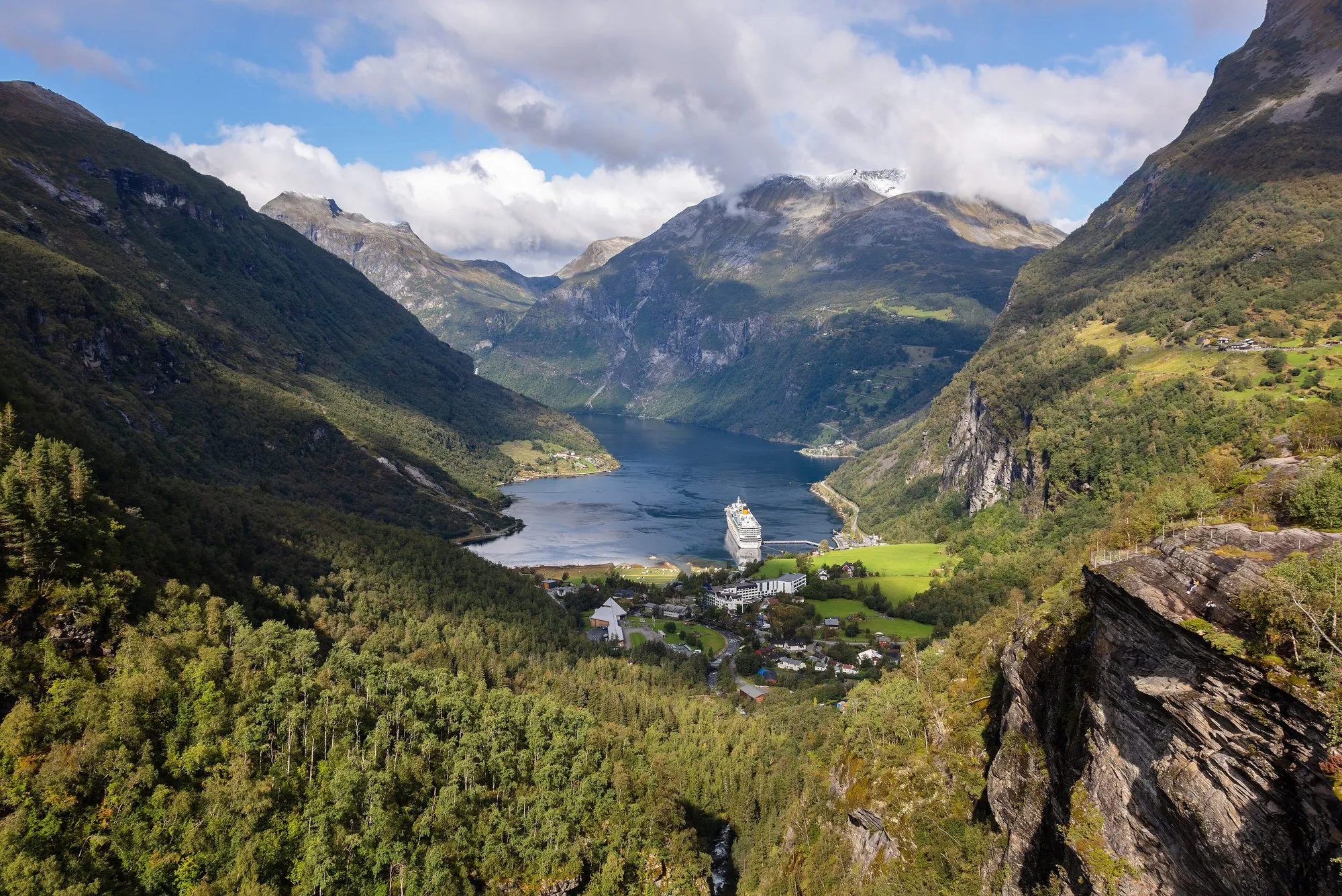
Flydalsjuvet: The Viewpoint Every Geiranger Bus Stops At
The famous overlook 4 km above the village. What is up there, which buses stop, and why you should not walk it.
Short answer
There is nothing to book here. Flydalsjuvet sits 4 km up Fv63 from the village, and it is a listed stop on the sightseeing buses that run up the mountain, from the 80-minute loop to the 3.5-hour Dalsnibba tour. Book any of those and the viewpoint is already in your day. The stop is the visit. If you were planning to arrange something separate for it, don't.
The viewpoint
What do you actually see from Flydalsjuvet?
Two platforms, an upper and a lower, joined by a walkway. The view is back down over the village at the head of the fjord, with your own ship in it. That last part is why this stop matters on a cruise day. Across the water stand Laushornet at 1,502 m and Eidshornet at 1,629 m, and the gorge below the viewpoint drops about 80 m.
The facilities date from 21 June 2006, when the site was rebuilt under the Norwegian Scenic Routes programme, with a service building of centuries-old timber. Toilets are open from mid-May to mid-October. Statens vegvesen lists the site as partially wheelchair accessible, which in practice means the platforms and the walkway, not the rough ground beyond them.
Norway's tourism industry has used this angle for decades. If you have seen one photo of a fjord village with a cruise ship in it, there is a fair chance it was taken from here.
Getting there
How do you get to Flydalsjuvet from the pier?
Three sightseeing buses leave the village, and every one of them stops at Flydalsjuvet. All three are on my main Geiranger page as cards. Prices are as listed in July 2026.
The 80-minute loop with audio commentary is NOK 750. It stops at Flydalsjuvet and the Norwegian Fjord Centre and never goes near the toll road, which makes it the shortest and cheapest way to this view. Check the 80-minute loop here.
The 2-hour panorama bus is NOK 885. Flydalsjuvet first, then up the Nibbevegen to the Dalsnibba Skywalk, then back down, with the toll included. Check the panorama bus here.
The 3.5-hour tour is NOK 1100 and adds the Eagle Bend after the summit. It meets between the pier and the public bus stop, and it carries a back-to-ship guarantee if you register your ship's name when you book. Do that. It is timetabled to end an hour before your ship leaves. Check the 3.5-hour tour here.
The operator's route description gives the Flydalsjuvet stop about ten minutes. That page is not dated to this season, so treat it as a photo stop and confirm the current timing at the tourist office before you build a plan on it.
On foot
Can you walk to Flydalsjuvet from Geiranger?
You can reach it on foot, and I would not on a cruise day. The road is 4 km each way with roughly 300 m of climb, there is no official walking route, and every coach in the village uses the same tarmac. The one marked alternative is a steep local trail from Vinje Camping, route K on the campsite's own hiking map, which walkers describe as slippery and easy to lose. Neither is worth your tender margin.
If you want to earn a view on foot, the Fossevandring waterfall steps in the village are the honest choice. They are in my Geiranger guide.
The skip
What should you skip at Flydalsjuvet?
The photograph. The famous frame, a person on the rock ledge past the railing with the fjord dropping away underneath, is taken outside the barrier. Local guides report visitors climbing over it most summers and the police getting involved. A fall from there kills you. The view from inside the fence is the same view. The ledge only adds a body to the picture.
And do not book anything sold as a Flydalsjuvet tour on its own. If a Geiranger product goes up the mountain, it stops here. Paying separately for the viewpoint is paying twice.
Weather logic
What if the weather closes the mountain?
Dalsnibba is the part of a mountain day that fails. The Skywalk sits at 1,500 m, is frequently in cloud, and the Nibbevegen toll road is seasonal, usually late May to October. Flydalsjuvet sits at roughly 320 m, below the cloud that kills the summit and below the toll-road turnoff, so a closed Nibbevegen does not close this stop. The operator's own bad-weather plan swaps Dalsnibba for a stop at Djupvatnet and keeps the rest of the route running.
That decides the bus. On a clear morning the 2-hour panorama bus is the best value for the two big views. On a grey one, do not pay for a summit you cannot see. The 80-minute loop still gets you Flydalsjuvet, and the money you saved buys a fjord cruise at water level, where the weather matters less.
Flydalsjuvet FAQ
Quick answers.
Do I need to book Flydalsjuvet separately?
No. It is not sold as its own excursion, and it does not need to be. It is a listed stop on the sightseeing buses that run up the mountain, and the stop is the visit.
How far is Flydalsjuvet from Geiranger?
About 4 km up Fv63 heading towards Grotli, with roughly 300 m of climb. There is no official walking route, so plan on a bus or a taxi.
Is Flydalsjuvet wheelchair accessible?
Partially, according to Statens vegvesen. Two platforms are joined by a walkway, and the toilets are open from mid-May to mid-October.
Can you see your cruise ship from Flydalsjuvet?
Usually, yes. The view looks straight back over the village and the anchorage, and a tendered ship sits mid-fjord in the frame. The local operator sells the stop as exactly that photo.
How I plan this guide
I base this page on official viewpoint and road information, the operator's published bus routes, and the conservative return-to-ship logic I use across Geiranger. I'm independent, not a cruise line, port authority, or tour operator. Return-to-ship safety always comes first.
- Reviewed 30 July 2026 · next review before the 2027 season
- Sources Norwegian Scenic Routes / Statens vegvesen (nasjonaleturistveger.no) for the platforms, accessibility, toilet season and peak heights; Fjord Norway for the distance and the 2006 rebuild; the operator's route descriptions (geirangerfjord.no) for the bus routes, stop length and the bad-weather substitution; the GetYourGuide listings for prices, meeting point and the back-to-ship terms; the local Geiranger Guide site for the 320 m elevation and the barrier warnings. Confirm prices, stop times and road status before relying on them.